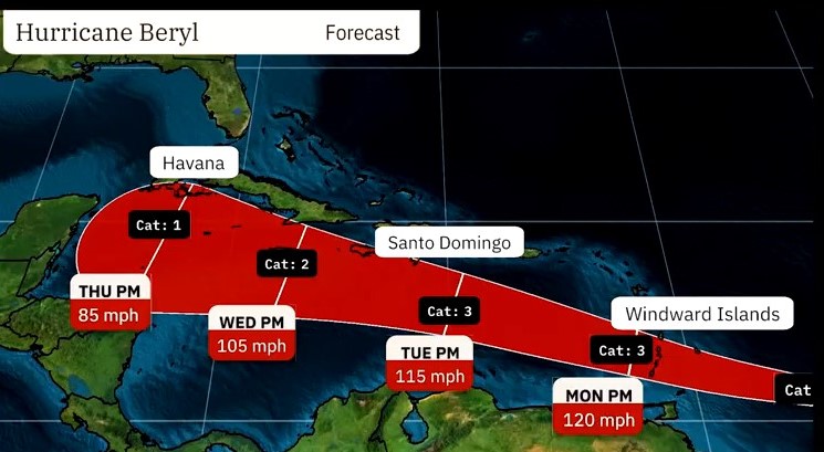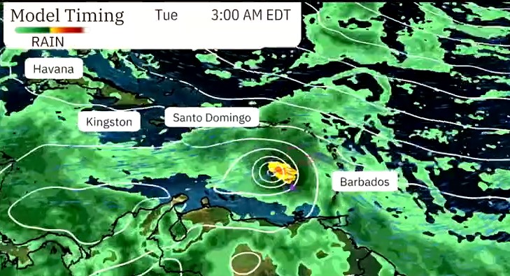
Hurricane Beryl projection provided by the Weather Channel
|
Getting your Trinity Audio player ready...
|
The National Hurricane Center reported this evening, Saturday, June 29, 2024, that Tropical Storm Beryl has become the first hurricane of the Atlantic season. It is expected to intensify quickly in its approach to Barbados and bring “life-threatening winds and storm surge.”
In terms of strength, the National Hurricane Center said Hurricane Beryl has maximum sustained winds of 75 mph and is moving west.
Hurricane-force winds extend outward up to 10 miles (20 km) from the centre, and tropical-storm-force winds extend outward up to 60 miles (95 km).
The estimated minimum central pressure is 992 mb (29.30 inches).
Due to the immediate threat to Barbados and the surrounding islands, the National Hurricane Center said the following watches and warnings are in effect:
A Hurricane Warning is in effect for:
- Barbados
- St Lucia
- St. Vincent and the Grenadine Islands
- Grenada
A Tropical Storm Watch is in effect for:
- Martinique
- Dominica
- Tobago
On the forecast track, Hurricane Beryl’s centre is expected to move across the Windward Islands late Sunday night and Monday.
The National Hurricane Center added that “A life-threatening storm surge will raise water levels by as much as 5 to 7 feet above normal tide levels in areas of onshore flow near where Beryl makes landfall in the hurricane warning and watch areas.”
Near the coast, the surge will be accompanied by large and destructive waves,
The National Hurricane Center continued.

According to the forecast track provided by the Weather Channel, Hurricane Beryl is expected to continue in the Caribbean, passing through Barbados and surrounding islands before moving toward Jamaica and the Cayman Islands.
All stakeholders in the region are urged to make hurricane preparations, stay prepared and stay safe. In addition, stakeholders must pay close attention to local weather stations and media for announcements.


