Cayman Government Issues Flood & Thunderstorm Warnings For Beryl, 7 am, July 4, 2024

7am Cayman Government Update
|
Getting your Trinity Audio player ready...
|
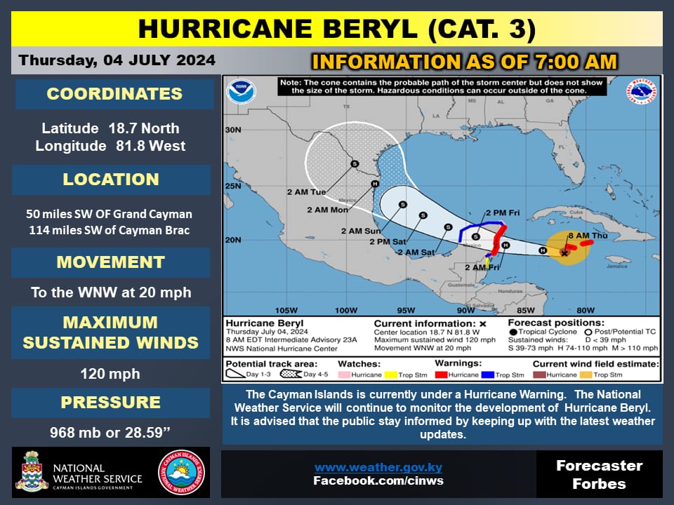
The Cayman Islands Government reported this morning, July 4, 2024, that “as of 7:00 am, Hurricane Beryl was located at 18.7°N, 81.8°W, approximately 50 miles SW of Grand Cayman and 114 miles SW of Cayman Brac.”
The Government added:
The hurricane is exhibiting maximum sustained winds of 120 mph and is moving WNW at a speed of 20 mph.
The minimum central pressure recorded is 968 mb (28.59 inches).
The Government noted at the time of the report that Cayman Brac, Little Cayman and Grand Cayman were experiencing tropical storm-force winds.
The Government explained that if the storm continues on its latest forecast track, expected weather conditions are as follows:
- Grand Cayman:
- Overcast skies with widespread thunderstorms are anticipated today. Grand Cayman is experiencing tropical storm conditions, which are expected to subside by this afternoon. Widespread flooding is anticipated with the risk reducing by this evening as Hurricane Beryl moves away from the Cayman area. Extremely rough seas, significant swells, and some storm surge is expected to peak during the morning and begin to subside by this evening. Rough seas are still expected through Friday.
- Sister Islands:
- Similar conditions of overcast skies and widespread thunderstorms are expected today. Tropical storm conditions over the Sister Islands have already begun to subside, with further improvement expected through the afternoon. Some flooding is anticipated, with the risk reducing from this evening. Extremely rough seas with significant swells are expected to continue to decrease through the afternoon. Rough seas are still expected through Friday.
The Government highlighted that a flood warning is in effect for the Cayman Islands.
Regarding this, the estimated daily rainfall was summarised as follows:
- Grand Cayman
- Thursday, 4 July: 50 to 100 mm (approximately 2 to 4 inches) with a potential for localized rainfall of 6 Inches.
- Friday, 5 July: less than 5 mm (approximately less than 0.2 inches)
- Saturday, 6 July: 15 to 20 mm (approximately 0.6 to 0.8 inches)
- Sunday, 7 July: 15 to 25 mm (approximately 0.6 to 1 inch)
- Monday, 8 July: less than 5 mm (approximately less than 0.2 inches)
- Sister Islands
- Thursday, 4 July: 76 mm (approximately 3 inches)
- Friday, 5 July: less than 5 mm (approximately less than 0.2 inches)
- Saturday, 6 July: 10 to 15 mm (approximately 0.4 to 0.6 inches)
- Sunday, 7 July: 5 to 25 mm (approximately 0.2 to 1 inch)
- Monday, 8 July: less than 5 mm (approximately less than 0.2 inches)
In addition to flooding, the Government explained that gusty winds are forecasted as follows:
- Grand Cayman
- Thursday Morning: E to SE at 50 to 60 knots (60 to 70 mph) with stronger gusts
- Thursday Afternoon: E to SE at 20 to 25 knots (23 to 29 mph)
- Friday Morning: SE at 10 to 15 knots (12 to 17 mph)
- Sister Islands
- Thursday Morning: E to SE at 25 to 30 knots (29 to 35 mph)
- Thursday Afternoon: E to SE at 15 to 20 knots (17 to 23 mph)
- Friday Morning: SE at 10 to 15 knots (12 to 17 mph)
Lastly, the Government said that a marine warning is in effect, and all vessels are advised to seek and remain in a safe harbour until further notice.
Concerning this, estimated wave heights were as follows:
- Thursday, 4 July: Waves of 10 to 15 feet accompanied by a storm surge of 2 to 4 feet, particularly along the south coasts of Grand Cayman.
- Friday, 5 July: Waves of 5 to 7 feet with swells, mainly along the south coasts.
The next Government update is expected in the afternoon of July 4, 2024.
{Source: Cayman Islands Government, July 4, 2024)