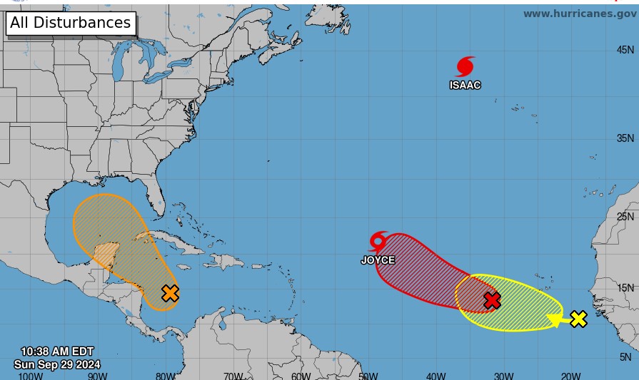
National Hurricane Center Forecast September 29 2024
|
Getting your Trinity Audio player ready...
|
By Alric Lindsay
According to a National Hurricane Center forecast this morning, September 29, 2024, two weather disturbances are coming off the coast of Africa behind Tropical Storm Joyce. Another is developing south of Jamaica and heading in the general direction of the Gulf Of Mexico.
One system is a tropical wave in the Eastern Atlantic near the coast of western Africa. It is expected to develop over the next week as it moves slowly westward or west-northwestward over the Eastern Atlantic Ocean. The formation chance through seven days is low, at 20 per cent.
The second system is AL90, a few hundred miles west-southwest of the Cabo Verde Islands. It may form as a tropical depression in a few days as it moves westward and then northwestward across the eastern and central tropical Atlantic. The formation chance through 48 hours is medium, at 60 per cent. The formation chance through seven days is high, at 80 per cent.
Ahead of these two systems is Tropical Storm Joyce, which is located at latitude 21.6 North and longitude 48.5 West.
Joyce is moving toward the northwest near 6 mph (9 km/h), and this general motion is expected to continue today. A turn toward the north is anticipated on Monday and Tuesday. Joyce is forecasted to become a tropical depression by Monday.
Another system is developing in the Western Caribbean Sea, below Jamaica and the Cayman Islands. This broad area of low pressure could become a tropical depression by the middle of the week as it moves west-northwest and then northwestward into the Gulf of Mexico. The formation chance through seven days is medium at 50 per cent.
Interests in and around the Caribbean should monitor these developments as forecasts may change anytime.

