Data from the National Hurricane Center over the past couple of hours shows that Hurricane Beryl is straddling between a category 3 and category 4 hurricane. This was the case as it slowed to category 3 at 120 mph and re-strengthened to category 4 at 130 mph today, July 1, 2024. Tropical Depression Chris and AL 96 are also in front and behind Beryl, respectively.
Hurricane Beryl
Regarding Hurricane Beryl, the National Hurricane Center said that today, as of 8 am AST, “the center of Beryl was located near 12.0, -60.5 with movement WNW at 20 mph.”
This put Beryl about 70 miles (125 km) east of Grenada and about 90 miles (165 km) south-south-east of St. Vincent.
The National Hurricane Center added that “The minimum central pressure was 959 mb with maximum sustained winds of about 130 mph.”
The National Hurricane Center explained further that hurricane-force winds extend outward up to 35 miles (55 km) from the center, and tropical-storm-force winds extend outward up to 125 miles (205 km).
In terms of impacts, the National Hurricane Center said, “Potentially catastrophic wind damage is expected where the core of Beryl moves through portions of the Windward Islands, with the highest risk of the core in St. Vincent and the Grenadines and Grenada.”
They added that “A life-threatening storm surge will raise water levels by as much as 6 to 9 feet above normal tide levels in areas of onshore winds near where the eye makes landfall in the hurricane warning area” and “Near the coast, the surge will be accompanied by large and destructive waves.”
Through this afternoon, rainfall is projected to be 3 to 6 inches across Barbados and the Windward Islands. In addition, about 10 inches are possible, especially in the Grenadines and Grenada. This rainfall may cause flash flooding in vulnerable areas.
The National Hurricane Center noted the following regarding advisories:
The government of St. Lucia has changed the Hurricane Warning to a Tropical Storm Warning for the island.
The government of Dominica has discontinued the Tropical Storm Watch for the island.
A Hurricane Warning is in effect for:
- Barbados
- St. Vincent and the Grenadine Islands
- Grenada
- Tobago
A Tropical Storm Warning is in effect for:
- Martinique
- Trinidad
- St. Lucia
A Tropical Storm Watch is in effect for:
- South coast of Dominican Republic from Punta Palenque westward to the border with Haiti
- South coast of Haiti from the border with the Dominican Republic to Anse d’Hainault
Tropical Depression Chris
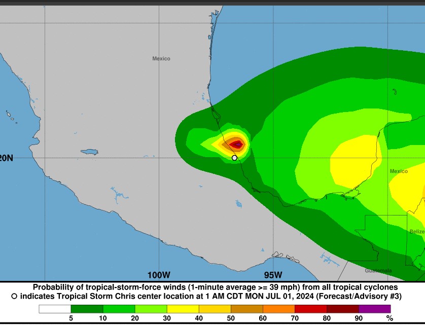
In the meantime, the National Hurricane Center reported that Tropical Storm Chris weakened to a tropical depression. This morning, Tropical Depression Chris was located at 20.2 North, longitude 97.7 West, about 60 miles south-south-west of Tuxpan, Mexico.
Maximum sustained winds are 35 mph and moving west.
The National Hurricane Center expected Chris to dissipate over the higher terrain later this morning.
Notwithstanding this, tropical Depression Chris is expected to produce rainfall totals of 4 to 8 inches across portions of eastern Mexico through this morning. Maximum rainfall totals of around 12 inches are possible across the higher terrain of the Mexican states of Guanajuato, Queretaro, and San Luis Potosi. This rainfall will result in areas of flooding, with mudslides possible in areas of higher terrain.
(Image source: National Hurricane Center)

AL96
Lastly, AL96 is following Hurricane Beryl and is producing showers and thunderstorms about 1,000 miles east-southeast of the Windward Islands.
The chance of formation as a tropical depression over the next seven days is medium at 60 per cent.
Concerning all of these developments, the National Hurricane Center said, “Interests elsewhere in the Lesser Antilles, Hispaniola, Jamaica, the Cayman Islands, and the remainder of the northwestern Caribbean should closely monitor the progress of Beryl.”
Stakeholders should also monitor local weather stations and media for updates.